|
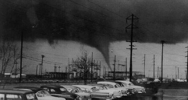
Dallas, April 2, 1957. Photo taken from the parking lot of Dresser Industries at the intersection of Illinois Ave. and Westmorland St., about 2 ½ miles to the west of the tornado’s path. View is east by northeast. The tornado is on Polk St. approaching -- or at -- Clarendon Dr. The condensation funnel has just succeeded in reaching ground level. (Thanks to Anita and Tony Davis for identifying the photographer’s location.) |
Narrative
Over the decades the history of the 1957 Dallas Tornado has become distorted in the re-telling. Certainly it was notable for its somewhat unorthodox south-to-north-to-northwest path of destruction (variously estimated to have been as much as one-hundred twenty-five to three hundred yards wide at some places) and its appearing to frequently and randomly drop down from and retreat back to the sky. However, when various reports of damage, loss of life, and observation of the funnel are assembled, and their locations plotted on a map, contradictions arise. Reports of the number of fatalities also have been inconsistent, even among official authorities.
To construct an accurate narrative of events it has been necessary to go back to contemporaneous sources. Current published material, and the Internet and Google, will not do the trick. The sources I have found to be the most useful are the April 3, 1957 issue of the Dallas Times Herald, and the Weather Bureau anthology "The tornadoes at Dallas, Tex., April 2, 1957 / a collection of reports" (referenced on the Links page).
Although what follows is by no means an exhaustive record of all instances of damage and injury, all deaths are accounted for. I have taken pains to pinpoint various locations of the funnel by noting specific street addresses or intersections wherever possible. The "Minute" titles approximately relate events being described to the official storm timeline from the Weather Bureau's report, with "Minute 0" representing the first signs of disturbance on the ground. The timeline was assembled substantially from Dallas Power and Light Company records of precise times when transmission lines were severed.
Footnotes are indicated by numbered links enclosed in parentheses and contain important material. Capital letters enclosed in square brackets are links to an extract from a 1981 Dallas County map with the corresponding locations marked (the map will open in a new browser tab).
------------------
PRELUDE My mother has told me that at about 4:15 p.m. CST on Tuesday, April 2, 1957 as she, my sister and I were leaving a grocery store close to our Wynnewood area home in the Oak Cliff section of south Dallas, I pointed to the sky and remarked on how strange it appeared. After taking a look for herself she agreed. The low cloud base seemed to be boiling. The atmosphere was in turmoil.
At about this same time(1) three or four miles to the southwest a Dallas County Sheriff's deputy sat at the intersection of Camp Wisdom Rd. and Cockrell Hill Rd. [A], on the northeastern edge of Duncanville. He had been studying with growing concern a rotating cloud mass -- the large updraft vortex, or mesocyclone, of a low precipitation supercell thunderstorm, although in 1957 he would never have heard the terminology -- approaching from south by a bit west across threatening skies(2). Gusty winds gently rocked his patrol car.
MINUTE 0 The mesocyclone passed him to the east, then, poised above the intersection of Camp Wisdom and Polk St. [B], made a turn north into Oak Cliff. The deputy set out after what appeared to him to be a "whirlwind," watching as the storm blew down a shed in the middle of a field.(3). Meanwhile, one or two observant photographers already had their cameras out and were capturing the earliest images of the storm.
MINUTE 5 The mesocyclone, now having taken form as an incipient tornado visible below the cloud base and making tentative advances toward the ground, established itself on what would be a six to seven mile northward path along Polk. More early reports from police officers and others began coming in.
MINUTE 6 With the tornado's arrival in the vicinity of U.S. Highway 67's intersection with Ledbetter Dr. [C], to the northeast of Red Bird (now Executive) Airport, its effects really began to be felt. A block to the northeast, near the intersection of Brookwood Dr and Channing Cir, the first significant damage to buildings occurred. As the tornado continued to move north over Polk, emergency vehicles were dispatched with lights and sirens. There was at the time no neighborhood-level weather emergency warning system.
MINUTE 7 Tradition, as much as actual reports, has the tornado (likely still mostly a wide, spinning vortex; a true condensation funnel may not yet have been clearly visible) initially reaching the ground near the intersection of Polk and O'Bannon Dr.(4) [D] Two blocks to the west my sister and I, only moments home from the grocery store trip, chased east down Grayson St. after a fire engine, siren screaming, hurrying south on Edgefield Dr. [E] I was thinking that, at age nine, I was going to see a real fire for the first time. The black, swirling debris high in the air over my head seemed good enough evidence for this. My mother stepped out of our house at the intersection of Grayson and Perryton Dr. and, noting whirling dirt and debris at ground level on the east side of Edgefield, sized up the situation quickly. She shouted to us saying that it was a tornado and to come back, and as we beat a hasty retreat I too could see a large amount of dust being blown up on Grayson in the block east of Edgefield.
The Sheriff's deputy continued to follow the developing tornado, observing it cross back and forth from one side of Polk to the other(5). A well-developed, visible condensation funnel made its appearance just south of Illinois Ave. At first the funnel did not reach all the way to the ground and displayed a freakish kink. The vortex still was making only sporadic contact with the ground, and small amounts of debris, from very isolated damage to homes that included one or two on Nicholson Rd just north of Saner, periodically sprayed up into the air. As my mother, my sister and I stood on a little hill in a neighbor's front yard on Grayson watching the funnel snaking about in the skies a mile to the northeast, all of this erratic activity had me convinced that it was coming back toward us. I was in tears, but my mother, knowing something of the general behavior of tornadoes, reassured me that it would not return to where we were (many years later she admitted that she was perhaps not quite so confident of this as she appeared at the time; the tornado gave her the impression that it was hunting madly for something, and that something -- in her imagination at least -- could have been her and her children).
MINUTE 10 The tornado seems to have played it coy as it progressed northward, only periodically dropping down to take a bite out of a roof here or some trees there. At 1002 DeWitt Cir, a block east of Polk's intersection with Illinois, it removed a portion of the roof while leaving an intact glass chandelier from some other location on the back porch. But at nearby 917 DeWitt Cir [F] it hit hard. A man and his 2-year-old daughter were caught outside and elected to lay down in a gutter as the funnel took its time tearing up a garage across the street. The daughter suffered two broken legs and the father required hospitalization as a result of their being blown about and hit by flying debris. These two apparently were the first injuries of any significance produced by the tornado. Many more were to follow.
An acquaintance of my mother's watched the tornado from the doorway of a nearby church, later complaining that it had given her a headache. This is not as unlikely as it may sound, as rapid and significant changes in atmospheric pressure were observed by others (a Weather Bureau employee twice heard a rubber duck spontaneously squeak as the funnel passed within half a block of his house).
The tornado was now gaining considerable strength. A couple of blocks to the northeast of Illinois and Polk, on Tyler St just north of Wilbur, a house was moved off of its foundation, the first example of this category of damage. There were to be many others, but most of them would see homes blown to pieces.
MINUTE 13 A few blocks further north matters turned deadly. At 919 Elmdale Pl. [G], also just a block east of Polk, a couple, the wife in her 80s and the husband 89, became the first fatalities at about the time the condensation funnel began making serious contact with the ground. The husband was killed outright, while the wife was to survive only long enough to give hospital workers her name.
The tornado, now disappearing
below the roofs and treetops from my vantage point, caused severe
damage to a home at 1039 S. Edgefield [H],
then back to the east to homes at the intersection of Burlington
Blvd. and Polk [I],
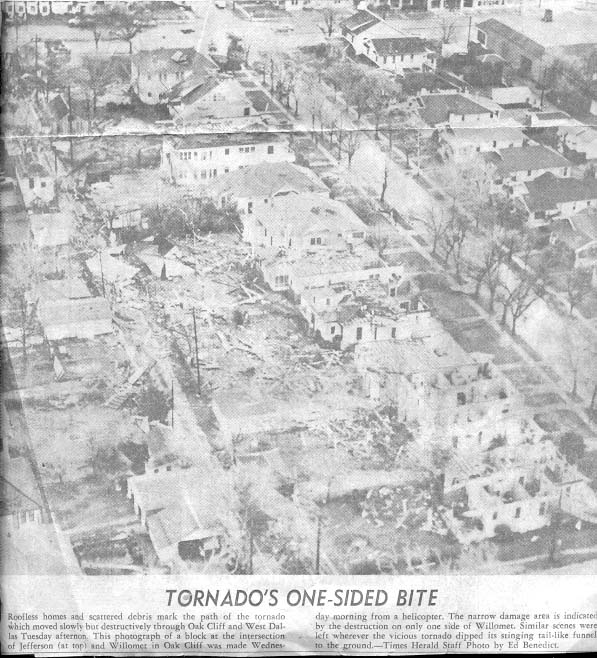
and a little further north to more houses at 515, 507 and 315 S.
Willomet St. [J]
(see photograph below).
MINUTE
14 Reports
then put it just to the northwest at the intersection of Edgefield
and Jefferson Blvd, after which it destroyed 36 homes and damaged 250
others plus six larger buildings near 7th St. and
Clinton Ave, one of them a movie theater located at Davis St.
and Clinton. [K]
A number of small fires were
started further north in the vicinity of Green and Edgefield as a
result of downed power lines. The tornado resumed its deadly nature
at Edgefield and Stewart Dr. [L]
Here a 55 year-old man working at a
Magnolia service station was crushed by a collapsing brick wall as he
took shelter in the building, making him fatality number three.
From
the Dallas
Times Herald,
April 3, 1957.
MINUTE 15 The persistent deputy, still trailing the tornado as it passed from Oak Cliff into scenic Kessler Park, noted houses losing roofs near Colorado Blvd. and Winnetka [M], the first real damage he personally was able to see. He didn't have any trouble seeing what happened next. The tornado was poised to deliver its full fury.
MINUTE 16 As it made its way from Kessler Park into West Dallas, finally diverging slightly to the west from its previous persistent northward track up Polk, an employee at a metals company on west Commerce St.(6), who had stepped to the door for a break, found himself suddenly suspended upside down, grasping for anything solid to hold on to. He survived. The deputy, now driving north on Hampton Rd., watched the funnel move into West Dallas and was struck by the massive amount of destruction that it began producing. Indeed the most extensive property damage of the entire storm was inflicted along a relatively narrow corridor that stretched from near the Texas and Pacific level grade crossing at Vilbig St.(7) north for about a mile and a half to the point where Navarro St. ended at Canada Dr. and the Trinity River's west levee (8) (also check the "Photo Sequence 2" link on the home page).
MINUTE 20 A warehouse was demolished at 1616 Singleton Blvd. [N] St. Mary of Carmel School was struck and damaged at 1716 Singleton, although classes fortunately had long been dismissed. As many as ninety-four homes and four apartment buildings were destroyed in the vicinity of Singleton's intersection with Vilbig. Forty-six of the homes were in the 3600 to 3800 blocks of Vilbig, where 45 injuries also were recorded. All of the houses on the west side of Vilbig between its intersections with Bayside Dr. and Homeland were leveled [O]. Homes also were destroyed on Bayside at 1802, nearby Leath Ave. at 1815, and Canada at 1843.
An apartment building at 1800 Canada had its walls flattened. A Dallas Transit Co. bus driver abandoned his Granada route in order to transfer about eighteen people, most of them apparently children and probably from this location, to Parkland Hospital (which was to escape being struck by just several blocks, and which admitted its first storm casualty at 4:50 p.m.). (9)
After days of soaking rains, the mostly dirt and gravel streets in this poorer section of the city were a morass. Significant numbers of victims were about to descend on Parkland, as well as on Methodist Hospital, and a large rescue effort was getting into full swing. Sight-seers, hearing about the tornado on live radio and TV broadcasts, were starting to flock in as well. Enormous traffic jams soon developed at the intersections of Singleton and Hampton, and Harry Hines Blvd. and Inwood Rd. Emergency vehicles faced a difficult challenge getting through to the hard-hit area.
MINUTE 27 Having done its worst in property damage, the tornado next prepared to do its worst in killing. It sliced north by a little west across the rain-swollen Trinity, reaching what the Weather Bureau later estimated was its maximum intensity and becoming for a short time a mesocyclonic version of a waterspout [P]. As it moved toward what then was known as the Industrial District, the deputy reported seeing a second funnel develop and quickly merge with the first(10).
MINUTE 28 The tornado roared into the modest Arlington Park neighborhood a few blocks to the west of Parkland Hospital, violently ripping apart many houses and flinging their debris into the sky as it advanced. It struck an apartment at 5712 Riverside Dr.[Q] (possibly 5715) taking the lives of three children from a single family, and seriously injuring their brother.
|
Arlington Park and Riverside Dr.[Q] in the late 1990's, still displaying evidence that the entire west side of the street, hosting a string of apartments in 1957, was wiped out. The apartment building at 5712 was located just below and to the left of the center of the image. The location of 5506 Pickfair Cir is along the center bottom edge of the image. The remnant of the C.R.I. & P. spur level grade crossing (13) can be seen on Record Crossing just west of the Riverside intersection. (Many thanks to James Fletcher for pointing me to online 1950s vintage aerial photographs corroborating much of this information.) |
A mother and her infant daughter died at nearby 5506 Pickfair Cir. The woman's son was reported to have been seriously injured. A two year-old from 5716 Riverside also was killed(11). The toll now stood at nine. What is perhaps the most famous and dramatic film footage of the tornado was made at this time.
MINUTE 29 One more victim, a sixty-five year-old woman from Oklahoma visiting her pregnant granddaughter, unknowingly awaited death at 7315 1/2 Harry Hines [R], just south of Love Field. The tornado seemed drawn to Harry Hines as it reached the thoroughfare near the Anson Rd. intersection [S] and began making its exit, taking that last life in the process.
It may have been waning in strength by this point, its tragic journey nearly at an end. There are reports of a police officer driving through the funnel somewhere along Harry Hines with no ill effects. As it began "roping out," the funnel's point of contact with the cloud base started to migrate significantly to the east of its point of contact with the ground.
MINUTE 30 It still carried enough energy, however, to cause damage at 2335 Burbank, and in the 2600 block of Love Field Dr. and the 7300 block of Hines Pl.; and to demolish a building at 2311 Burbank [T]. There is a single report of an aircraft being destroyed on the ground at Love Field(12). A recreation center at 2619 Love Field Dr. had most of its windows blown out, though none of the children inside were injured. There are reports of it tearing up natural gas lines on Love Field Dr. On the nearby Missouri Kansas Texas railroad line, a boxcar was flipped on to its side(13) [U]. The roof collapsed at the Johnson & Johnson plant at 9000 Denton Dr. shortly after employees had been evacuated (see item on “Links to Other Sites” page). There was a bit less damage done at 2224 Burbank: a 2 x 4 was shot through a wall into the living room and that was it.
MINUTE 32 The sheriff's deputy, whose odyssey had so closely paralleled that of the tornado, was on Harry Hines -- for a short time in pouring rain -- not far behind as the funnel passed over Bachman Lake and near to 2934 Shorecrest Dr. [V] He skirted the lake northwest of Love Field and followed the rapidly weakening tornado north three or four miles along Lemon Ave. It seems that it produced some final damage to houses at Northwest Highway. Then, near the city limits of Farmers Branch, the great Dallas tornado of 1957 finally died.
DIMINUENDO The city was just beginning to comprehend the magnitude of the event, to be measured in shattered buildings, traumatic injuries flooding hospitals, and, of course, the dead -- so many of them children. The deputy's adventures, however, were not over. He spotted another funnel -- spawned, as it turned out, from the same supercell almost immediately upon the tornado's demise -- further north, in far south Collin County, and tracked it for a while as it headed off toward the Red River before he eventually returned to Duncanville where he had first eyed that threatening cloud.
(1) Some reports
erroneously place the time of first sighting at close to 3:00 p.m.
This appears to
be a vestige of the confusion created by the flawed April 2,
1997 Dallas
Morning News article
mentioned elsewhere on this site. The 1960 Weather Bureau [now
National Weather Service]
technical
report on the storm referenced on the Links page marks the time of
the first good photograph of the mesocyclone at 4:26p.m. CST, which
corresponds with "Minute 0" to within 30 sec - 1 min.
Back
(2)
Police and other emergency personnel had been put on special alert
for potential severe weather. For several days preceding April 2 the
area (there was no "DFW Metroplex" in those days) had
experienced copious amounts of rainfall. Local reservoirs were
approaching record levels. Tornadoes had occurred further to the
west. The April 2, 1957 issue of the Dallas
Morning News noted
that a cold front was pushing east, and that a significant spring
snowfall was predicted for the Panhandle. Newspaper reports even
suggested that the continuing bad weather might disrupt a special
election scheduled for Tuesday to fill a vacant U.S. Senate seat. The
National Weather Bureau in Kansas City had issued a severe weather
watch for Tuesday for an area stretching from just west of Fort Worth
to West Texas. Dallas was about thirty miles to the east of this
area. Back
(3)
There are only a few recorded reports describing the storm's
appearance or activity -- and just 2 or 3 photographs of it --
during the first ten to twelve minutes of its life. [On
this site the term "storm" generally refers to the tornado
specifically, but here I intend it to have the broader meaning of
"supercell/mesocyclone/vortices/tornadoes."]
The April 3, 1957,
issue of the Dallas
Morning News cites
police sources as saying that the tornado split into two funnels near
Ledbetter and 67, one proceeding north along Polk and the other
moving off to the northeast. As noted later, the storm did spawn
multiple vortices at various times; but there was only one funnel,
once it touched the ground, identifiable to onlookers as the tornado
[but
see also next note].
Back
(4)
Purists will note that the definition of a tornado is any single
instance of a supercell mesocyclone reaching the ground. Thus the
tornado technically was multiple tornadoes. However, throughout this
site I speak of it in the singular [see
also previous note].
The funnel (as opposed to the damage path) was estimated to have had
a maximum width of about 125 ft. The April
3, 1957 issue of the Dallas
Morning News claims
that the funnel first touched down in Cedar Hill, several miles to
the south of the Polk and O'Bannon location. This is almost certainly
not correct, although Cedar Hill possibly was the location where the
rotating cloud mass originated. [One
of the things meteorologists discovered while studying the tornado
was that damage can occur when there is no condensation funnel
visible to onlookers as touching the ground. There was another
tornado in the area the next day, April 3. It developed south
of Dallas, perhaps near Cedar Hill, and moved from southeast to
northwest before dying out over the now defunct Amon Carter Field,
south of the present DFW International Airport. It produced no damage
or casualties.]
Back
(5)
I have spoken with someone who lived along this part of Polk in 1957
who says that, after the storm, damage was present on only the east
side of the road and not on the west. Back
(6)
Some reports, including Dallas television station WFAA's November,
2005 "Wild Weather Week," have the funnel barely skirting
downtown Dallas. Actually it was never closer to the west end than
about two miles. [The
WFAA report contains some clips gleaned from film footage of the
tornado and its aftermath. In the accompanying animation the
track is erroneous in several places, and appears to completely
bypass Arlington Park to the north. I emailed Troy Dungan about this,
but got only a canned response. Live WFAA radio reports on April 2
featured reporters mentioning how close the tornado appeared to them
to come to downtown, which may represent the original source of this
error.]
Back
(7)
It was at about this point that photographers at numerous locations
around the city begin to collect the bulk of their historic
documentation of the storm. A short piece from the April 15, 1957,
issue of Time
about an NBC
photographer who produced one of the best film records can be found
here.
Back
(8)The
April 3, 1957 issue
of the Dallas
Morning News, the
1997 DMN
fortieth anniversary
article, and a web page on stormtrack.org
all claim that three people died in the vicinity of Singleton and
Vilbig [a
mother and her two children according to one anecdote].
The Weather Bureau technical report -- an obviously detailed,
scholarly, and solid recapitulation of the event -- claims that
"most of the injuries and loss of life" happened in this
area. By the official tally, though, no more fatalities after the man
at Edgefield and Stewart were to occur until the tornado had moved to
the other side of the Trinity. It does not appear possible to
reconcile this apparent discrepancy by assuming that three of the
locations where people died that are reported on the present site are
actually in error. Addresses for 9 victims -- available from
contemporary sources -- are known, and the death of the man at the
gas station has been too widely reported to stand any chance of being
a mistake. That leaves no potentially misplaced victims to cover the
three putative deaths in the Singleton-Vilbig area. There is very
little chance that the official death toll has been under-reported --
the historical record contains no ambiguity concerning this number.
My opinion is that, reputable (and not so reputable -- see "The
Dallas Morning News Stories" elsewhere on this site) claims to
the contrary not withstanding, the Singleton-Vilbig deaths never took
place, although this issue certainly deserves more research. All and
not just some of those who were victims of this event deserve to be
remembered. And, rightly or wrongly, history tends to rate tornadoes
by the number of people they kill. [See
also Note 11.]
Back
(9)
Coincidentally, Parkland had
held a disaster drill at its 2 1/2 year-old Harry Hines facility only
the Friday before. The hospital subsequently was praised for its
skillful handling of the disaster. One of the physicians in charge of
trauma care turned up at his post at the ambulance entrance quite
promptly -- he had seen the approaching tornado from his office
window. Back
(10)
My mother recalls seeing secondary vortices form only to quickly
dissipate. Back
(11)
Not all of the victims perished immediately. The last to go
apparently was this two year-old, who died at 8:07 a.m.
April 3 in Parkland
Hospital. The
stormtrack.org page mentioned in Note 8 implied that only two
children from one family died in Arlington Park.
However, there definitely were three from one family -- probably the
tornado's best known victims -- and almost certainly not two from any
other family [see
also Note 8 for other confusion concerning fatalities].
Back
(12)
A military surplus P-51D owned by a Jacksboro, Texas, rancher.
Ironically, the owner is said to have used the plane, as well as
others, to fly severe storm reconnaissance for the Weather Bureau.
Back
(13)
One witness reported at some point seeing a boxcar tumbling end over
end. A rail car on a C. R. I. & P. spur at Riverside and Record
Crossing (in the same Arlington Park neighborhood where six
people were killed), loaded with bricks, was moved some
distance by the tornado, a feat which, according to the Weather
Bureau technical report, an engineer calculated had required winds of
~217mph (which is in the F4 category). Back
Last updated 6 August, 2018