|
Appendix (Complete content of Web page, put up on May 27, 2003 and taken down about a year later. There were no figures or images — but see the bottom of this page for examples from the CAIB's final report. The references to "the CAIB 's March 17 Ground Track and Events Summary map" should have read "March 13." The WFAA broadcast video was, as it turned out, not EOC2-4-0118, and it does not seem to have made any appearance in the investigation under any other identity. The Apache FLIR GPS clock was indeed checked during the course of the investigation and found to be set correctly and operating properly. The reader who finds the following abstruse should bear in mind that its only intended audience was the NASA JSC Earth Sciences and Image Analysis Laboratory group.)
TIME
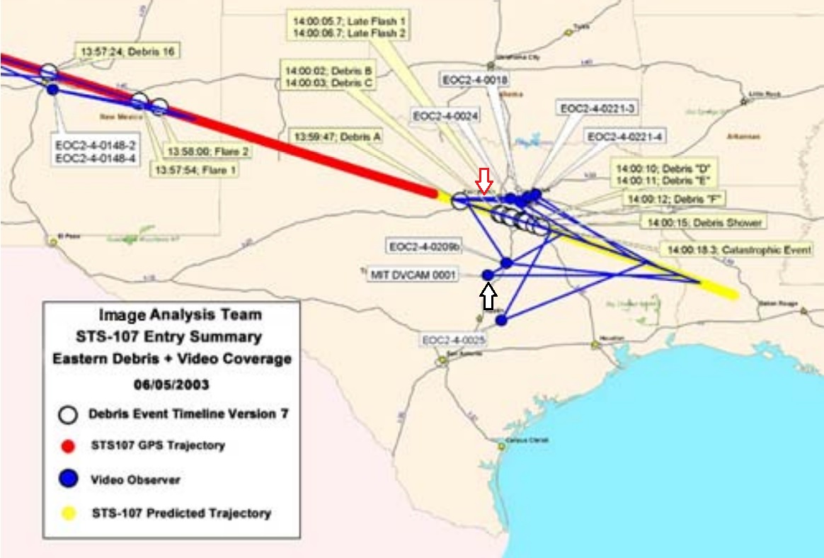
From what I understand, the 13:59:59 number was arrived at primarily, if not entirely, by matching an event or events documented in my video with the same event documented in a second video containing GPS time stamping. This second video would almost certainly have to have been from the forward looking infrared targeting system on the Apache helicopter at Ft. Hood. However, the CAIB's March 17 "STS-107 Accident Investigation Ground Track, Events Summary, and Sighting Data" map suggests that the two videos' overlap for only 1 or 2 seconds at the very end of my video's coverage of Columbia when it is far away, the camera is zoomed out, and the image is at a very poor resolution. It is possible that events in the Apache video were matched to a third video, which was in turn matched to mine. Either of these procedures seems to offer ample opportunity for mismatching which could explain the error. The Apache's FLIR GPS clock also might have been inaccurate or malfunctioning. It would be interesting to know if it was checked against any other standard.
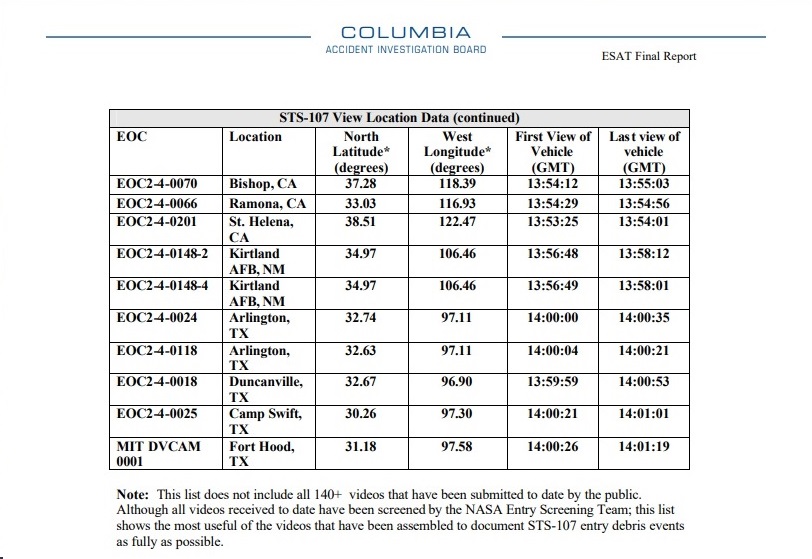
Local television station WFAA was broadcasting live Columbia's passage south of the DFW area. This video was professionally made and has, as I recall, lengthy coverage at a good resolution. It would necessarily be timed accurately. It is not represented on the Ground Track and Events Summary map. Perhaps it is the video numbered EOC2-4-0118 that is referred to in the CAIB's March 10 Rev 15 Master Timeline. I am not sure to what extent, if any, it has been used in the video analysis. In any event, it would seem potentially to be a good candidate for resolving differences of opinion over timing.
DIRECTION
Columbia's ground track lay at 280 degrees from me at 13:59:30.7 GMT, the time of its last telemetered GPS location. At that time it was at a distance of 128 miles from me and known to be traveling east by southeast (i.e., on a geographic heading of about 110 degrees). It is difficult to contrive an estimated extension of the ground track from this last known location that would have Columbia lying at 270 degrees at 13:59:59 while not having it pass overhead of me, which it did not do.
When Columbia was due south of me its elevation was, by my later estimation using ground structure references, greater than 45 degrees but much less than 90 degrees. At an altitude of 38 mi (200,000 ft), if its ground track when it was due south of me was -- as is implied by every ballistic model, debris footprint/recovery map, and estimated ground track that I have seen -- 30 miles away, then by calculation its elevation was 52 degrees.
By my observation, then, Columbia's ground track passed from the west to the southwest to the south to the southeast of me. As an eyewitness to the event -- an eyewitness who, like others, paid particularly close attention since I was photographing it -- I am confident that Columbia's actual ground track after telemetry was lost was quite close to and not significantly north of the estimates that have been made public, including the CAIB 's March 17 Ground Track and Events Summary map.
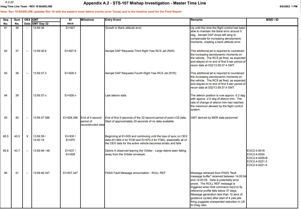
Assuming, based on these arguments, that the various (and quite similar) projected ground tracks/debris footprints for Columbia that have been made public are all essentially the same as its actual ground track on February 1, then by the hypothetical ballistic model ground track as represented on the Ground Track and Events Summary map my estimated AOS would be 13:59:46, consistent with the 13:59:44 time noted in the section above.
Significantly, the time when Columbia was due south of me as documented in the video using the 13:59:44 AOS and the time when it was due south of me based on the hypothetical ballistic model ground track as represented on the Ground Track and Events Summary map are both 14:00:09 GMT. In other words, the 13:59:44 AOS supports the ballistic model very well, while the 13:59:59 AOS does not.
GEOMETRY
CALIBRATION
OF CAMERA CLOCK
At about 10:15 a.m. CST on February 1, using a stopwatch, I compared the difference between the minute rollover on my camera's TOD clock and the same minute rollover on the clock on my cable TV converter box (which I have found in the past to be very stable and reasonably accurate). By this method the camera clock was 11 sec behind the cable converter clock. On February 2 it occurred to me just to tape the cable converter clock with the camera time and date display turned on. I made three of these comparisons spread over several hours and included them with the VHS dub of my video that I sent to JSC on February 3. Over subsequent days I made more of these comparisons, and I discovered that my camera's TOD clock was not stable (although it was always behind the cable converter clock). This made it apparent that the 11 sec difference measured on February 1, shortly after the events recorded on the video had occurred, was the best measurement to use.
Next I made several comparisons of the cable converter clock to various cable television sources. For instance, I taped The Weather Channel (which has a continuous display of time of day to the second) and my cable converter box simultaneously. These measurements showed that the cable converter clock was consistently running 2 sec behind cable television time sources. On February 6 I tuned WWV (the National Bureau of Standard's shortwave broadcast of time of day) on a shortwave receiver, and by ear and eye determined that the cable converter clock was also 2 sec behind WWV. The 11 sec difference between the camera's clock and the converter box clock plus this 2 sec accounts for the 13 sec difference between the camera's clock and the actual time of day mentioned in the first section above. (Tables and figures from the Columbia Accident Investigation Board's final report:
|